Geospatial Services & Digital Solutions
Geomatika Technology provides integrated geospatial services covering GIS application development, mapping, data conversion, remote sensing, imaging, consultation, training, and R&D.
Application Development
Application development is one of the main activities in our company. We simplified data manipulation procedures with powerful customized software functions tailored to local requirement. We are also developing the Geographic Information System for local authorities throughout Malaysia.
Having the principals originated from the surveying and mapping profession, Geomatika has a strong foundation in handling land-related data especially geo-referenced spatial data. This capability together with expertise in software development engineering has positioned us to develop sophisticated GIS surveys mapping system in the country.
With the constant evolution of computer technology, Geomatika has seen that the only way to improve timeframes and efficiency is to continuously upgrade and improve our computer systems and updating it now and then.
Current and Previous Projects
- Road Information System
- Asset Management System
- Land Information System
- Geodata Management System
- Land Valuation System
- Computerized and Multimedia System
- Local Authority Computerized GIS System
- Web-based Project
- National Infrastructure for Land Information System
Technologies We Support
Technologies that Geomatika Technology specialize and provide support. These technologies are extensively used in the applications developed by Geomatika.
 PostgreSQL
 PostGIS
 QGIS
QGIS
 Docker
 GeoServer
 MapProxy
 OpenLayers
 Solr
Solr
 Node.JS
 ZeroMQ
 GDAL
GDAL

Mapping Services
Geomatika uses state-of-the-art technology and requirements to produce digital products to meet the specific needs of your project. We offer a wide range of products and services to meet all your photogrammetric needs.
- Aerial Photography
- Digital Photogrammetry
- Digital Terrain Models
- Photogrammetric Consulting
- Topographic Mapping
- UAV Mapping
Data Capture and Conversion
We are used to convert data into digital form. We possessed four units of A0 size digitizer and on the fly software. We are also converting digital data captured in one system then transfer them into another system by providing customized software to translate.
We acquired the latest soft photogrammetry software like VirtuoZo, PCI and ER Mapper for vector and raster topographic and orthophoto development from aerial photographs and remote sensing data. We possess the Wild Aerial Camera and authority in hyperspectral mapping in Malaysia.
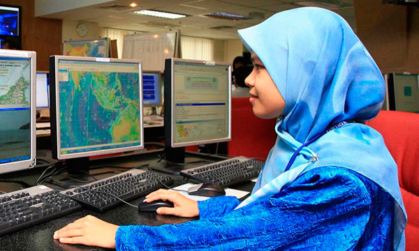
Remote Sensing and Airborne Radar
Our company also offered services specializing on remote sensing and geographic information sensing applications. Geomatika has been using ERMapper on a number of projects for Malaysia Government bodies. Geomatika multidisciplinary staffs offered expertise in remote sensing and have executed numerous projects involving image processing and interpretation.
To make sure that we have dedicated workers in remote sensing, our company usually send its workers to seminars and training to enhance the quality and of course to give the best services to our clients.
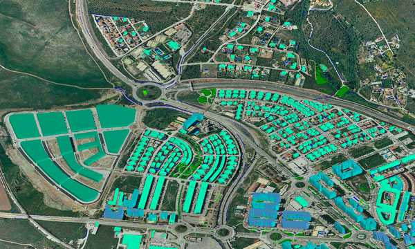
GIS and Data Services
Our company multidisciplinary staffs offer specialists in GIS and has executed numerous projects worldwide involving spatial data management. Geomatika is offering the entire line of OPEN SOURCE software such as QGIS, GeoServer, PostgreSQL, PostGIS, Mapnik, MapProxy, Jasper Reports, Open Layers, GDAL/OGR, NodeJS, and many more.
We provide assistance with the selection, accuracy and potential uses for virtually all types of geographic digital data. Geomatika has available GIS ready spatial data.
Available GIS Ready Spatial Data
- Digital Cadastral Data of Federal Territory of Kuala Lumpur, Malacca, Johor, Selangor and Perak.
- Digital Topographic data 1:5000 for Federal Territory of Kuala Lumpur and major towns.
- Digital Topographic data 1:25000 for Selangor, Kedah, Perlis and Johor.
- Digital Topographic data 1:2500 covering Kuala Lumpur and Multimedia Super Corridor.
- GPS Ready-Data for major cities in West Malaysia.
- Remote Sensing Data 1:5000 landsite imagery for all states.
- Digital Orthophoto for major towns in Malaysia.
Imaging Services
We offer users and resellers a fully integrated imagery solution and services.
Imagery Solution and Services
- Hardware and software solution, color and B/W.
- Imaging implementation and consultancy.
- Raster Scan Services, color and B/W.
- Raster to Vector Conversion.
- Auto-Vectorization and Digitizing.
- Complete Document Management, Index and Archiving.
- Customized Format Conversion.
- Document Workflow Management.
- Customization of Electronic Document Management System.
Scan Index Archive in One Process
- Direct Scanner Interface.
- Scan and Index directly to ODBC compliant database.
- Advanced multi-page management.
- Network based document management and workflow engine automated document archive and workflow control.
Consultation
With vast experience in digital, spatial data handling, software development and spatial software usage, we provide consultation to the following fields.
- Local Authority GIS Integrated System
- LIS/GIS/FM/NaLIS implementation and database design
- Digital Data Capture and Conversion Specification
- GPS Mapping Specification such as utility, forestry, TEN, Telekom etc.
- Digital Mapping
- System Integration
- Remote Sensing
- Hygrometry
- Business Process Engineering
- Urban Management
- Road Inventory Management
- Land Use and Planning
- Research and Development
Center of Excellence for GIS Training and R&D
Malaysia Premier GIS and Remote Sensing Training Center
The CEGIS Training Center provides convenient, high quality professional training which significantly enhance productivity with a range of products. Our training fees is lower compared other training fees in the market. Still, we provide the highest and one of the best quality of trainings.
Professional Training
Ongoing training is vital to your organization professional growth and success. Whether you see success as a quicker way to increase your productivity or gaining that valuable edge skills and get promoted, the CEGIS Training Center can help. Certificates of Achievement are provided to all participants. Our future training will be web-based technology.
Need geospatial support for your project?
Contact Geomatika Technology to discuss mapping, GIS, application development, data conversion, and spatial information management needs.